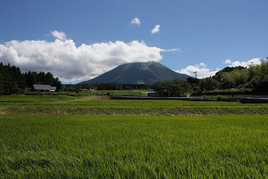
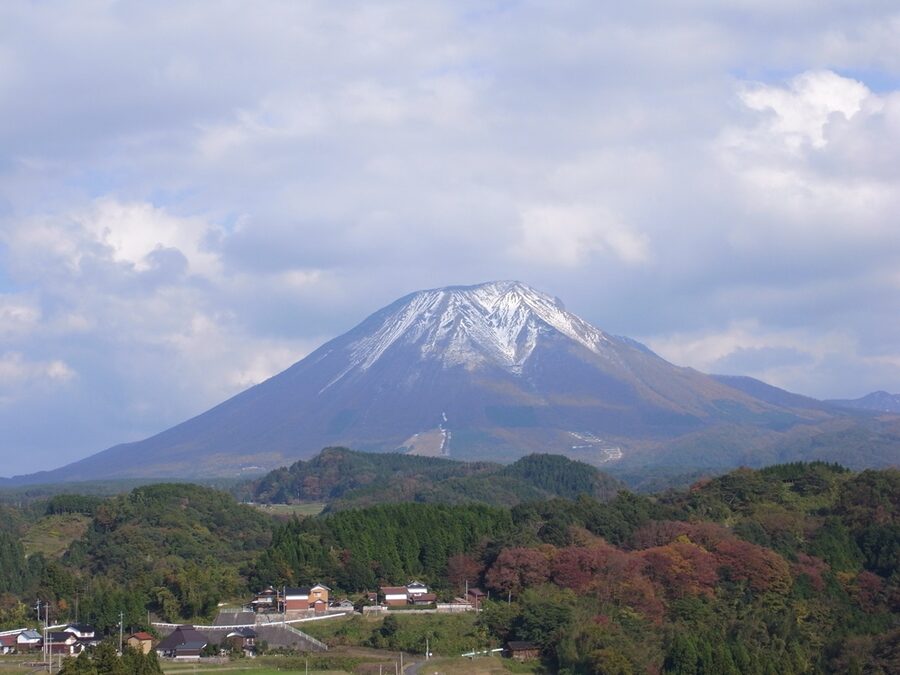
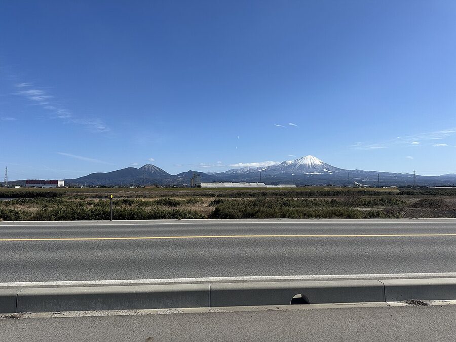
Mt Daisen (大山) is the only serious mountain in the Chūgoku region. At 1,729 metres it’s the tallest peak between the Japan Alps and Kyūshū — nothing else in the five prefectures of western Honshū breaks 1,500 — and its sharp conical shape, visible from 50 km in any direction, has been venerated since before the Japanese written record. It has a nickname: Hōki Fuji, “the Mt Fuji of Hōki,” referring to the old Hōki Province that covered modern Tottori.
The comparison is apt. Like Fuji, Daisen is an extinct stratovolcano with a near-perfect conical silhouette from the west. Unlike Fuji, it has barely any visitors outside Japan — maybe 50,000 hikers a year, overwhelmingly Japanese, compared with Fuji’s 300,000+ — which means the trails are clear, the mountain huts don’t book out, and the summit is a working hike rather than a queued procession.
Daisen is 20 minutes east of Yonago by bus, 40 minutes east of Matsue, and directly accessible from the San’in coast railway. It is an easy day trip from any base in the region, a full-on mountain-hiking trip if you want to summit, and — in winter — a small but genuine ski resort. This page covers all three.
The mountain’s geography

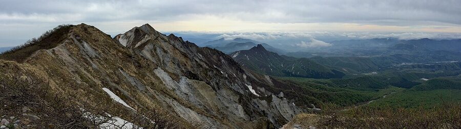
Daisen last erupted around 17,000 BC — comfortably extinct, with zero seismic activity since the Tertiary era. The mountain’s rock is andesite and dacite, forming a classic stratovolcano cone that’s been eroded over millennia into a ridge-line running east-west. The highest point, Kengamine (剣ヶ峰), is officially off-limits due to ridge instability; most hikers summit at the adjacent and only slightly lower Misen (弥山, 1,709 m), which has a proper summit platform.
The mountain’s lower slopes are covered in one of the most important mixed broadleaf forests in Japan — beech, Japanese maple, oak, and Japanese horse chestnut — that becomes a major kōyō (autumn-foliage) destination in late October and early November. The alpine zone above 1,400 metres is short scrubby pine and bare rock.
Hiking the mountain
The standard summit route is the Natsu-yama Tozan-dō (the “summer mountain trail”) — a 6-km round trip, 900 metres of elevation gain, 4 hours up and 2½ hours down at a reasonable pace. The trail starts at Daisen-ji Temple (see below), climbs through beech forest for the first hour, emerges into alpine scrub at 1,400 metres, and reaches Misen summit at 1,709 m.
The trail is well-marked and well-maintained but surprisingly steep in the upper sections — the last 30 minutes are essentially a wooden boardwalk up a 30° slope. You don’t need technical climbing skills, but you do need good shoes, a proper rain jacket (weather changes fast), and about 1.5 litres of water. A single mountain hut — Kirisaki Hutte — operates at the 1,500 m level during summer; it’s primarily a coffee-and-cake stop.
Season: mid-April through mid-November for the summer trail. From December to March the trail is buried and should only be attempted with proper winter gear and a guide.
Autumn foliage (kōyō) peak is late October through the first week of November. This is the single best time to come — weather is crisp, the lower beech forest glows orange, summit visibility is unusually good.
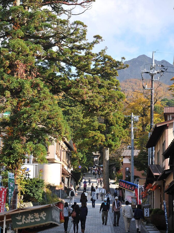
Daisen-ji Temple
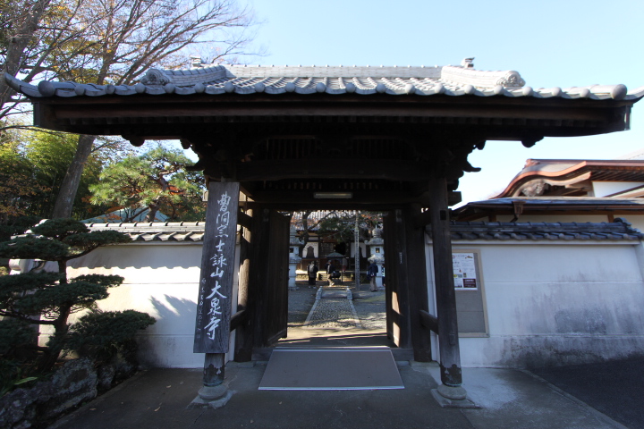
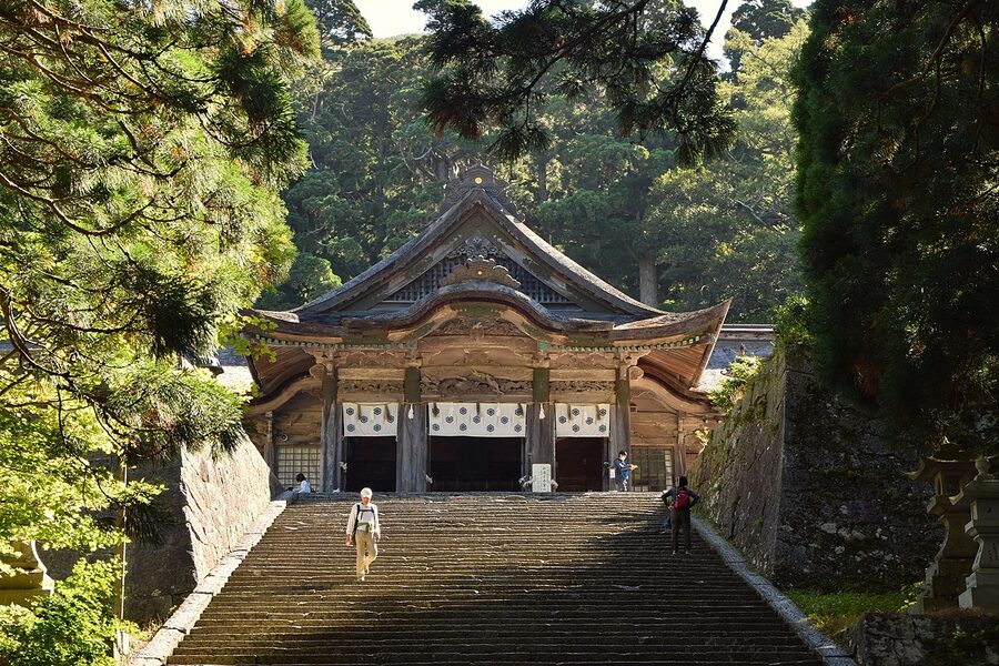
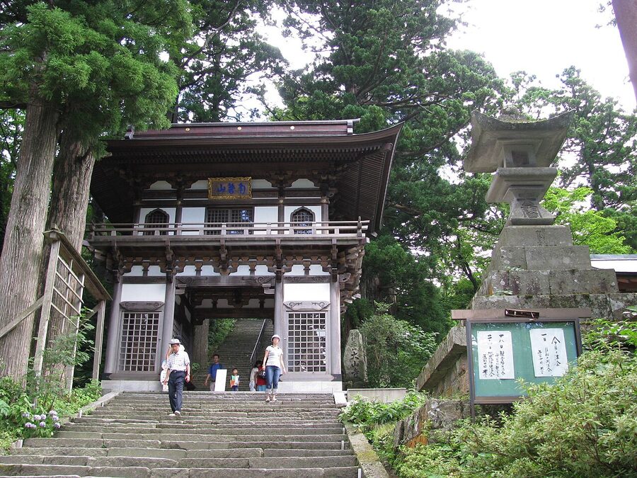
At the base of the summit trail — and the starting point for every hike up — is Daisen-ji (大山寺), one of the oldest Tendai Buddhist temples in Japan. Founded in 718 AD by the monk Kinren Shōnin, the temple has been the centre of Japanese mountain worship for Daisen for 1,300 years continuously.
At its medieval height in the 12th–14th centuries, Daisen-ji had 100 sub-temples spread across the mountain’s slopes, 3,000 monks, and was one of Japan’s three great mountain religious centres alongside Mt Kōya and Mt Hiei. It was also a training centre for yamabushi — mountain-ascetic monks whose practice still continues in small numbers today.
Modern Daisen-ji is a working temple with about 20 resident monks. Most visitors see only the main hall (entry ¥300, 09:00–16:00), but the temple’s side halls — particularly the small Kannon-dō and the pilgrim hall — are worth the extra 30 minutes. Look for the 14th-century Tetsusoutsu Nōkyō-zō (a bronze Buddha surrounded by 10,000 miniature Buddhas, designated an Important Cultural Property) in the main hall.
The adjacent Ogamiyama Jinja Shinto shrine is a separate institution from the temple but sits on the same grounds — one of the few remaining examples of pre-Meiji shinbutsu shūgō, the syncretic Buddhist-Shinto practice that dominated Japanese religion for 1,200 years before the 1868 imperial decree that split them.
The ski resort
From early December through late March, Daisen runs as a small but proper ski resort — the largest in western Japan. Two lift systems, 27 runs, a total of 270 hectares of groomed terrain at altitudes between 800 and 1,300 metres.
The resort isn’t Hakuba-scale — it’s a regional ski hill with a loyal following of skiers from the San’in coast, Hiroshima, and Osaka. But the snow quality is surprisingly good (the west-facing slope catches wet winter storms off the Sea of Japan), the crowds are almost entirely local, and a day pass runs ¥4,800, which is less than half the Niseko equivalent.
Equipment rental at the lodge is ¥3,500 for the day. Instruction in Japanese only; English instruction is available by pre-booking through the tourism office.
The Daisen Park Scenic Road
For non-hikers, the Daisen Park Scenic Road circles the mountain’s northern and western slopes at about 800 metres elevation. It’s 37 km total, with 12 official viewpoints, and takes about 90 minutes to drive at a slow pace. The best two viewpoints: Kagami-ga-Naru (on the north side, best sunset composition) and Taki-yama (the western viewpoint with the full cone view).
The road also runs through the Daisen-Oki National Park, which extends from Daisen west to the coast and includes Izumo and — across the water — the Oki Islands.
The four seasons on Daisen
Daisen runs harder through its seasons than any mountain in western Japan, and what you get depends heavily on when you come.
Spring (April – early June). Alpine flora peak: the daisen-kyaraboku (Daisen yew) forest around the summit is one of only two places in Japan where this specific conifer grows wild. Mid-May wildflowers — yukiwariso, shakunage rhododendron, yamazakura cherry — carpet the lower meadows. Hiking paths reopen in sequence as the snow melts: the Natsuyama (Summer Trail) from mid-April, the Furusato-dani (Fall Valley) from mid-May, the alpine-ridge paths only by mid-June.
Summer (July – August). Peak hiking season. The ridges are clear; the summit view reaches 200 km on a good day; Daisen-ji and the ski lodges are open with full service. The mountain is popular with domestic summer hikers but never overrun — you’ll pass maybe 50 other people on the standard Natsuyama route on a busy Saturday. Temperatures at the trailhead are 22-26°C; at the summit, 12-16°C. Bring a windbreaker even in August.
Autumn (October – mid November). The single most photographed window of Daisen’s year. The beech forests below the timberline turn red and gold; the kyaraboku stays green, producing a specific Japanese colour contrast you can’t replicate anywhere else in the country. Peak foliage is usually 20 October to 5 November. The Masumizu Plateau below the temple is the classic autumn photograph.
Winter (December – March). The mountain closes to summer hiking. Ski and snowshoe operations take over. The Daisen-ji zazen meditation programs continue year-round — sitting in an unheated cedar-beam temple hall in January with snow piling on the roof is a particular kind of spiritual experience and one of the more memorable winter activities in western Japan. Book the temple’s 2-day Shukubō stay (¥12,000 per night, full board, vegan monastic meals) through the tourism office.
Hiking routes, in detail
Five marked routes reach the main ridge. In rough order of difficulty:
Natsuyama-tozandō (夏山登山道, 6 km one-way, 3-4 hours up, 500 m start elevation, 1,710 m summit elevation). The standard route. Well-marked, stone steps for the first half, then wooden boardwalks to protect the summit alpine vegetation. Mid-grade fitness required. Toilets at the Rokugome (6th station) hut halfway up. Most people need 2-3 hours down as well.
Gyoja-tozandō (行者登山道, 6.5 km, 4 hours up). Quieter alternative route, joins the Natsuyama route at the 6th station. Runs through the Ashibuchi-no-Sawa gorge and past three small waterfalls. Slightly harder than the Natsuyama path but prettier.
Daisen Traverse (9 km, 6-8 hours one-way). The full ridge traverse from Yumigahama to Kagami-ga-naru, crossing Misen and Kengamine. Japan Alpine Club-grade — exposed ridge sections, helmets sometimes recommended, no rescue service covering these routes. Not for casual hikers. If you do it, book a local guide through the Daisen Nature Centre.
Daisen-ji pilgrim path (3 km round-trip, 90 minutes, no summit). The easy option. From the car park at Daisen-ji, a walk up through old-growth cedar to the inner temple at the treeline. Paved, mostly flat. Good for non-hikers.
The summit rule: As of 2018, the actual peak Kengamine (1,729 m) has been roped off. The wooden observation deck at Misen (1,709 m) is now the official “summit” for casual hikers. This is because the narrow ridge between the two peaks has been eroding since a 2000 earthquake, and the Ministry of Environment declared the last 200 metres unsafe. Respect the rope. The view from Misen is essentially identical.
Daisen-ji at the autumn festival
The temple’s main annual event is the Saitō Dai-Goma-Kuyō, a large outdoor fire ritual held on the last Sunday of October. Monks build a pyre of cedar logs about three metres tall; chanted mantras accompany the lighting; thousands of small wooden prayer plaques are thrown onto the fire as it burns. The smoke is believed to carry the prayers skyward. The ceremony runs 13:00-15:00; the temple grounds are crowded (this is genuinely one of the most significant Shingon Buddhist rituals in western Japan) but visitors are welcome. Free.
Getting there
From Yonago. The Daisen-ji bus runs from Yonago Station to Daisen-ji in 50 minutes, ¥760 one-way. Services roughly hourly during summer, fewer in winter.
From Matsue. Train to Yonago (20 minutes) then bus. Total about 90 minutes door-to-door.
From Okayama or Hiroshima. Shinkansen to Okayama, Yakumo limited express to Yonago (2h 20), then bus. This is a long day; staying overnight in Yonago or on the mountain makes more sense.
By car. Yonago IC on the Yonago Expressway → 20 minutes to Daisen-ji. The Daisen Park Scenic Road is only accessible by car. If you plan to do the scenic road loop, rent a car in Yonago or Matsue.
Where to stay
Daisen White Palace. Mid-range ski lodge converted into a year-round hotel, 5 minutes from the ropeway. ¥12,000–¥18,000 with dinner.
Daisenji Shukubō. Temple-stay option run by Daisen-ji. ¥9,000 with vegetarian dinner and morning meditation. Book 30 days ahead.
Pension Yukai. Small family-run lodge on the lower slope. ¥10,000 with breakfast. English-speaking owner.
Or stay in Yonago or Matsue and day-trip.
Planning your visit
Half-day. Daisen-ji temple + the Kagami-ga-Naru viewpoint + tea at the lodge. Good if you’re on a wider San’in itinerary and can’t spare the full day.
Full day, no hike. Daisen Park Scenic Road (car needed), Daisen-ji, Ogamiyama shrine, lunch at the lodge, back.
Full day with summit hike. Start at the trailhead by 08:00, summit by 12:00, descent by 15:00, post-hike soak in the Daisen onsen, back to base by 18:00. Demanding but rewarding.
Winter ski day. Same transport pattern as summer; rental and lift tickets at the lodge. Best snow mid-January through late February.
One moment to remember
Stand on the Misen summit platform at 09:00 in late October. The maple and beech colour runs down the mountain’s slope in every direction. To the north, the Sea of Japan is hazy blue; you can sometimes see the Oki Islands 60 km out. To the south, the Chūgoku mountains roll away toward Hiroshima. A stiff wind comes over the ridge from the Sea of Japan. Nobody around you is speaking English.
This is the view that earns the climb. Nothing else in western Honshū gets you this height, and nowhere else offers this combination of alpine and coastal geography in a single panorama. Pack a sandwich, take 20 minutes, and pay attention.